Friday, 2 July 2021

Day 77 Kroombit Tops 2

 Friday 2nd July, 2021 24.7km

Can you see where I've been?

1980.2 / 3118.7km

11 weeks since I started in Cooktown.

Today is a walk across station tracks that is also the southern way into the Kroombit Tops from Monto. I think the major road must come from Calliope as I couldn't imagine those caravans at Griffith Creek coming up this way.
The creek needs a good flow

The rain comes in patches and I'm a little worried as I haven't been able to get much charge into my electronics in the past couple of days, and a few more days to come apparently.

The walk just meanders across the Plains following Munholme Creek, another creek that hasn't had a flow for a while. 6 years I found out later.
A Prickly Pear in a stump


I meet the owner of Stony Creek Station, the property I've been going across. It was a difficult conversation as I mumble and he was deaf. He doesn't see too many walkers apparently. I wonder what he would think if it became popular.

The official campsite is at the back end of the Cannia Dam. I decide to move further up the road which is now an official road and thus a road reserve to play in.
Stony Creek Station

A family in a Toyota pass me. They had passed me this morning on the way to Kroombit. About 5 minutes up the road the father had stopped and is pumping up the tyres. They had not gone all the way up as it was getting wetter and the hard clay bits on some of the steep slopes was very slippery. I stopped for a chat and we talked about the walk, what I ate etc. Then the wife does the unthinkable and offers me one of hubby's beers. A quick glance at hubby to make sure and I accept. It's a Byron Bay something but I chug it down fairly quick as I don't want to carry the bottle. She offers me a softdrink as well and I take a Sunkist Orange for dinner. I refuse the bread and everything else she offers. Kind people from Bundaberg at Cania Gorge for the wet weekend. Forgot to get their names. But much appreciated.
Dead Man's Bend


I meet the owner of the property where the official camp is. He doesn't think the water reserve exists any more. Something the National Trail people should follow up as there have been a couple of these reserves that seem to be incorporated into properties and the lack of use might be reinforcing their belief they no longer exist. We talked about the rain due. He was hoping for Creek running rain, I'm not so much. I ask him to think of me as it rains on his roof tonight.
We share water. I like it when the valve is exposed
as I don't have to dip into the trough.

A few more km under my belt this afternoon shortens tomorrows walk and I find a spot beside a fence the cows have conveniently flattened for me, kick a few poos aside and all is good.
I set up the tent in the rain which involves setting the groundsheet and fly up first then putting everything under to do the rest in the relative dry. Putting up this way helps pulling it down in reverse in the morning if it's raining.
A wooden grid


My night fluid, new hat and a pair of pliers
I picked up.


Thursday, 1 July 2021

Day 76 Kroombit Tops

The forest is getting thicker

Thursday 1st July, 2021 18.6km

The rain settled in last night. It was the first time I had to pack inside the tent proper pulling the inner out and leaving the fly last. I'll have to make sure I set it up tonight for the wet pull down.
Fog and drizzle has settled in so it's a no to a return back north to the escarpment walk. I set off down the road and the country changes to a more rainforest feel. The creeks though look like they haven't run in a while so a good down pour would not go astray.
Moving into rainforest

It's a pleasant walk with the rain getting heavier and as I get closer to the escarpment I can hear the wind blowing a gale.

Tree ferns

I get to the lookout and it's all in fog so I see nothing. The road then begins dropping away as you come down the range. The rain eases a bit and as my notebook is packed away to keep dry, I miss a supposed dam. The notes talk about logging trucks and I come across a memorial to a logger killed but I assume now it's a National Park the logging has stopped. I get down to the bottom of the range and the suggested camp is a bit of ground before the grid to exit the park. There is of course no water in the creek so I keep moving into the cattle station and eventually find water from a bore that tastes surprisingly good.
It's while I'm sitting here a Ute rolls up and I meet Chris. We have the usual chat and he seemed surprised by me walking. He then tells me he is a rock climber. Now I think those people are a bit strange, walking is easy and I get the belly wobbles at any height.

Decided not to take the tourist drive
We have a bit of a chat and he offers me a hat. Dr Brian would be happy so I accept. He did ask if I wanted anything and I said it's funny I get cravings for a fizzy drink (I think in a previous blog I said people are welcome, if they see me, to throw cans at me as long as they are Pepsi Max and are cold and full).

Also the next stop is at Mungungo Pub where I hope the kitchen is open (not on Mondays) and a burger is on the menu. We part ways and I head off looking for the next stealth camp as the next official camp is 20 km away and I think this is not a gazetted road and there is no road corridor. In the end I find a nice flat spot. Another drizzly night on the cards. The hat worked well in
wet and slippery
keeping drizzle out of my face. The weather is due to get worse tomorrow.


Memorial to Glen Hocky, a logger 
who died in 1994


Checkout the Elkhorn in the tree

Yes it does. I will come back in a car.

New Hat. Thanks Chris


Wednesday, 30 June 2021

Day 75 Griffith Creek Kroomit Tops

Up away early

 Day 75 Wednesday 30th June, 2021 16.5km

1936.9 / 3162km

I was planning a shortened day with all the walking uphill but the weather moving means I'm unsure of what to expect.

Open forest as I get to the top
So it's an early rise and getting on the roller coaster again as we slowly gain height. It gets wetter as I get higher so the plan is always being mulled over in my head. I need to get water and have been told that there is water at Griffith Creek, also the ranger station has a rainwater tank but I've been told that the tap might not be accessible.

Eventually I get to the top. I'm camping up here tonight. The ranger station is 1.6 km to my left Griffith Creek 600m to my right. I decide to go to Griffith Creek to find the "reliable running water" is a muddy puddle from last night's rain. There is a tank but it is bore water and smelly, worst I've smelt on this trip. There are three caravans here but nobody home to ask . So whilst I take some of the bore water I move off to the south to the next creek that apparently runs clear.

Of course it's
Open forest as I get to the top
another creek that hasn't run in a long while. But since it goes through a rocky patch just after the road there are pools of water that are coloured by tannin but overall are good. I pour out the bore water and filter a couple of litres for my night camp and move off. Another stealth camp as I'm not walking back to Griffith Creek. I find a small knoll off the road and the ground is fairly level so I set up behind a fallen tree away from most other trees knowing the weather is moving in tonight.
I got disturbed by a group of pigs coming through but a bit of a noise and light from me have them high tailing it back down the hill. It rained lightly most of the night.
The reliable water at Griffith Creek


Griffith Creek camp

Elkhorn

the rocky creek water

The filtering but tasted a lot better than the bore

My camp spot

Still some climbing to do


Day 74 Kroombit Tops National Park

Tueday 29th June, 2021 21.4km

The tops in the distance

1920.4 / 3178.5 km

The old Kroombit camp
So today is the day I climb the range of Kroombit Tops National Park. I spent a lot of time when planning this walk, working through the notes and plotting the route in google earth only to find out later the route has changed to the Razorback Fire Trail. There are no notes or updates on the website, a problem the National Trail people will have to fix if they want the trail to become popular.

I walked past the Old Kroombit camp and wonder why it was here. It could be a good spot for
someone to set something up for us trail travellers... we don't want for much - flat ground and a hot shower is always nice, inexpensive is best.

I then pass into Lochenbar station roads that take me eventually to the bottom gate of the National Park with a small meander along a creek till I come to Marble Waterholes, the last good water before climbing the range. The track goes up and over two hills and ends up back on the creek. From what I could see the track went round these hills but obviously the creek washed it away so it's been replaced by a, for us walkers, a PUD (pointless up and down). The first one straight
Thataway through the station
after the gate into the park I could put up with, it's not that big. But the second one I thought was the beginning of the tough climb and goes a long way up only to lose it all and wind up back at the creek.

Then you have to do it all again at least this time only losing a little height each time you think you've crested. I gave the day away when I had climbed about 300m to about 770m with the top of the range being about 900 metres. A Suzuki Vitara went past me at one stage so in dry weather it's not a hard climb. The hard clay though is like glass when it gets wet and it's the sort of stuff I broke my coccyx on when I fell on the Heysen.

Marble Waterholes. A good spot to camp.
I found some fairly level ground and set up camp close to a prickly pear. The thing dropped bits all
night frightening the beejeesus out of me a couple of times. Little bit of rain predicted over the next couple of days.

Climb up only to see the track go back down again
Looking West from the lookout
Gaffer Tape repair


The camp under the Prickly Pear


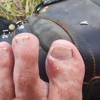
Toe operation. I think I've managed to stop
the ingrown nail.


Tuesday, 29 June 2021

Day 73 Kroombit Creek

Dropping the key back and the view to the station
Monday 28th June, 2021 22.4km

1899 / 3199.9km

The state of origin wasn't much chop. I'm a blues supporter but I would like a better contest for these games.

It was a cool clear morning and I had about 23 kilometres to cover but I wasn't in a hurry. I had hard boiled my remaining eggs and toasted the rest of the bread I had for breakfast. The eggs went into the bag for later. I still have 3 orange's left as well. Makes the pack a little heavy but I can't bring myself to leave it.

Losing the hat isn't going to make Dr Brian,
my skin man happy
I'm on the road by about 7.30am. I have to walk back up to the trail which is about 8 kilometres. I get there and have breakfast and then I'm on the trail proper. It's a station road that meanders across the foothills and eventually comes out on a road from Biloela (apparently derived from an Aboriginal word for white cockatoo).
The road out


It's here I met a man (I'm sorry I forgot his name) and chatted a little about the trail. He has a family member planning on doing the trail with a donkey. I gave him my name and the unicorn page in case she wants to follow for interest. We chatted for a fair while and I could have probably picked up another job if I wanted. There is a shortage of people in the country everywhere. In the end we shook hands said our goodbyes and went our separate ways.

My eggs for breakfast

The road then meanders through some cattle properties. The suggested camp is a crossing on Kroombit Creek but since the notes were written (1991) they have built a dam and Sunwater has then dropped its no camping signs everywhere. The property people here are keen to post private property signs everywhere and the local property workers rolled up as I was looking at the water I was going to have to filter and asked all the usual questions and then reversed and went back the way they come. Meaning they probably saw me and came to chat. So it was a stealth camp I was looking for. In the end I was still in front of the dam on high ground behind some fallen trees.
A mouse/rodent decided to visit and chewed its way into the tent and was chewing its way into my breakfast stash. A little gaffer tape covered the hole. I won't be selling this tent on gumtree I suppose.

Mt Kroombit

I shared my last apple with this pair

The dam wall from my camp

These blokes are good for reconciliation. They obviously
understand a connection to their land.


Monday, 28 June 2021

Day 72 Calllide Dam

Weather much more suited to Tasmania

Sunday 27th June, 2021

A Zero Day

A Cold Day

I spent it cleaning and packing and generally getting everything ready to go again in the morning. The next leg is 6 or 7 days with a big climb through the Kroombit Tops National Park.
A good lazy day and they played a State of Origin on a Sunday for me.
Not much to report.


This is mid afternoon. I think the lady
was running out of
gear to put on
so she
wore a dressing gown


My clothes in for a soak

Next load of food


The pack drying


Washing my pillow
  
I woke up at 5am or so and worked out I could
charge off the TV usb albeit slow


Day 250 Mondo Yards to Donnellys Weir (Healesville)

  VIC Day 26 (250) Sunday 30th January, 2022 18.5km 5330km I slept like a log. I can remember falling asleep as I was typing my diary. Wasn...