Wednesday, 30 June 2021

Day 75 Griffith Creek Kroomit Tops

Up away early

 Day 75 Wednesday 30th June, 2021 16.5km

1936.9 / 3162km

I was planning a shortened day with all the walking uphill but the weather moving means I'm unsure of what to expect.

Open forest as I get to the top
So it's an early rise and getting on the roller coaster again as we slowly gain height. It gets wetter as I get higher so the plan is always being mulled over in my head. I need to get water and have been told that there is water at Griffith Creek, also the ranger station has a rainwater tank but I've been told that the tap might not be accessible.

Eventually I get to the top. I'm camping up here tonight. The ranger station is 1.6 km to my left Griffith Creek 600m to my right. I decide to go to Griffith Creek to find the "reliable running water" is a muddy puddle from last night's rain. There is a tank but it is bore water and smelly, worst I've smelt on this trip. There are three caravans here but nobody home to ask . So whilst I take some of the bore water I move off to the south to the next creek that apparently runs clear.

Of course it's
Open forest as I get to the top
another creek that hasn't run in a long while. But since it goes through a rocky patch just after the road there are pools of water that are coloured by tannin but overall are good. I pour out the bore water and filter a couple of litres for my night camp and move off. Another stealth camp as I'm not walking back to Griffith Creek. I find a small knoll off the road and the ground is fairly level so I set up behind a fallen tree away from most other trees knowing the weather is moving in tonight.
I got disturbed by a group of pigs coming through but a bit of a noise and light from me have them high tailing it back down the hill. It rained lightly most of the night.
The reliable water at Griffith Creek


Griffith Creek camp

Elkhorn

the rocky creek water

The filtering but tasted a lot better than the bore

My camp spot

Still some climbing to do


Day 74 Kroombit Tops National Park

Tueday 29th June, 2021 21.4km

The tops in the distance

1920.4 / 3178.5 km

The old Kroombit camp
So today is the day I climb the range of Kroombit Tops National Park. I spent a lot of time when planning this walk, working through the notes and plotting the route in google earth only to find out later the route has changed to the Razorback Fire Trail. There are no notes or updates on the website, a problem the National Trail people will have to fix if they want the trail to become popular.

I walked past the Old Kroombit camp and wonder why it was here. It could be a good spot for
someone to set something up for us trail travellers... we don't want for much - flat ground and a hot shower is always nice, inexpensive is best.

I then pass into Lochenbar station roads that take me eventually to the bottom gate of the National Park with a small meander along a creek till I come to Marble Waterholes, the last good water before climbing the range. The track goes up and over two hills and ends up back on the creek. From what I could see the track went round these hills but obviously the creek washed it away so it's been replaced by a, for us walkers, a PUD (pointless up and down). The first one straight
Thataway through the station
after the gate into the park I could put up with, it's not that big. But the second one I thought was the beginning of the tough climb and goes a long way up only to lose it all and wind up back at the creek.

Then you have to do it all again at least this time only losing a little height each time you think you've crested. I gave the day away when I had climbed about 300m to about 770m with the top of the range being about 900 metres. A Suzuki Vitara went past me at one stage so in dry weather it's not a hard climb. The hard clay though is like glass when it gets wet and it's the sort of stuff I broke my coccyx on when I fell on the Heysen.

Marble Waterholes. A good spot to camp.
I found some fairly level ground and set up camp close to a prickly pear. The thing dropped bits all
night frightening the beejeesus out of me a couple of times. Little bit of rain predicted over the next couple of days.

Climb up only to see the track go back down again
Looking West from the lookout
Gaffer Tape repair


The camp under the Prickly Pear


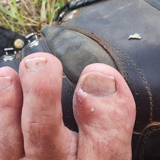
Toe operation. I think I've managed to stop
the ingrown nail.


Tuesday, 29 June 2021

Day 73 Kroombit Creek

Dropping the key back and the view to the station
Monday 28th June, 2021 22.4km

1899 / 3199.9km

The state of origin wasn't much chop. I'm a blues supporter but I would like a better contest for these games.

It was a cool clear morning and I had about 23 kilometres to cover but I wasn't in a hurry. I had hard boiled my remaining eggs and toasted the rest of the bread I had for breakfast. The eggs went into the bag for later. I still have 3 orange's left as well. Makes the pack a little heavy but I can't bring myself to leave it.

Losing the hat isn't going to make Dr Brian,
my skin man happy
I'm on the road by about 7.30am. I have to walk back up to the trail which is about 8 kilometres. I get there and have breakfast and then I'm on the trail proper. It's a station road that meanders across the foothills and eventually comes out on a road from Biloela (apparently derived from an Aboriginal word for white cockatoo).
The road out


It's here I met a man (I'm sorry I forgot his name) and chatted a little about the trail. He has a family member planning on doing the trail with a donkey. I gave him my name and the unicorn page in case she wants to follow for interest. We chatted for a fair while and I could have probably picked up another job if I wanted. There is a shortage of people in the country everywhere. In the end we shook hands said our goodbyes and went our separate ways.

My eggs for breakfast

The road then meanders through some cattle properties. The suggested camp is a crossing on Kroombit Creek but since the notes were written (1991) they have built a dam and Sunwater has then dropped its no camping signs everywhere. The property people here are keen to post private property signs everywhere and the local property workers rolled up as I was looking at the water I was going to have to filter and asked all the usual questions and then reversed and went back the way they come. Meaning they probably saw me and came to chat. So it was a stealth camp I was looking for. In the end I was still in front of the dam on high ground behind some fallen trees.
A mouse/rodent decided to visit and chewed its way into the tent and was chewing its way into my breakfast stash. A little gaffer tape covered the hole. I won't be selling this tent on gumtree I suppose.

Mt Kroombit

I shared my last apple with this pair

The dam wall from my camp

These blokes are good for reconciliation. They obviously
understand a connection to their land.


Monday, 28 June 2021

Day 72 Calllide Dam

Weather much more suited to Tasmania

Sunday 27th June, 2021

A Zero Day

A Cold Day

I spent it cleaning and packing and generally getting everything ready to go again in the morning. The next leg is 6 or 7 days with a big climb through the Kroombit Tops National Park.
A good lazy day and they played a State of Origin on a Sunday for me.
Not much to report.


This is mid afternoon. I think the lady
was running out of
gear to put on
so she
wore a dressing gown


My clothes in for a soak

Next load of food


The pack drying


Washing my pillow
  
I woke up at 5am or so and worked out I could
charge off the TV usb albeit slow


Sunday, 27 June 2021

Day 71 Biloela

I go over, the pack goes under

Saturday 26th June, 2021 50.3km (6.5walking)

1876.6 / 3222.3km

The morning comes and it's drizzling, I'm in the clouds, it's cold but the wind isn't causing an issue.
I pack up and then over the many locked gate. I know I have to drop some elevation and checking the satellite it's really just a walk down the Speciman Hill Road to Coal Road. There is a couple of weather systems converging and it's expected that up to 25 mm of rain is due today.
The track down

When it's not drizzling the fog moves in. I'm looking for a pretty faced wallaby which is supposed to be in this area and I think I spy one through the fog.

The track has been graded in the worst bits and I can hear machinery working further down. It appears there was a crew working on the gas pipeline area putting in some water management berms. I then spy a familiar truck across the road when I get to Coal Road. Is Don Is Good (old Don commercial). Maybe I can get my hat back.

I cross the road and sit under a tree which diverts a lot of rain and boil the billy and eat an orange and wait to hear some movement from the van.

Fog rolling in. I took the picture because the
sign says please shut the gate but they were
open and I didn't want to wear any blame.

I finally hear movement and knock on the door and Don greets me happily, more probably that he had guessed right about where I might appear rather than my seeing my rugged good looks.
We discuss the walk down and what I couldn't see and I look in the truck for my hat but have no luck. So it seems I've lost it somewhere else.

As a steady drizzle settles in I decide to accompany Don again down Coal Road. I have checked into the Callide Retreat Caravan Park where my next food drop is so I just need to he there sometime after lunch.

I found an old brick


We act like a couple of old tourists and end up going up the lookout over the power station and coal mine. I offer to pay for a pub lunch if he wants to drive into Biloela and Don doesn't seem like a man that passes up many free lunches.

That I believe is a pretty face wallaby

We have a very mediocre parmigiana at the hotel but a lot more interesting conversation. Biloela is putting on a multi cultural festival after lunch today. The rain might make it uncomfortable and after a coffee which was much better than the parmigiana, we head back out to the retreat.
Once more Don and myself part. I don't think we will meet again until I get to Victoria as it's cold here and Don is not heading any further south. It's been a pleasant diversion from the trudging and the discussions we have had have covered many topics. Don was a lecturer for 25 years or so he says. I reckon he is still going just needs a another couple of ears occasionally.

The cabin is ready and I'm ready to get in out of the rain and cold and the first thing on is the heater. Matt the manager of the retreat has picked up some groceries and a 6 pack of beer for me and I pick up the box of food I left. It means I can cook some food over the next couple of days and not raid my walking food. I've run out of everything by the time I get here except the dehydrated stuff.

Don

I spend the afternoon cleaning and washing. The more I get done today the more relaxing day I get tomorrow. I wash everything including boots and pack to get some of the stink off. The clothes I put in for a heavy duty soak and the colour of that water even shocked me. I made those lovely white socks a light shade of blue though. All the ladies will shake their head but a separate wash for two socks just isn't on my radar. I was able to sit down and watch some mindless television. The phone charger blew up altogether here and I have to come up with a plan until I can get another one.


Callide Power Station
Callide Dam

Day 71 only 6.5km walking and a lot of driving, into Biloela and back.


Saturday, 26 June 2021

Day 70 Collard Creek - Don

Friday 25th June, 2021 47.6km
All I found of the ruins mentioned in the guidebook


1865 / 3233.9km

Even though I thought I slept in I was still packed and ready by 7am. Onto my second cup of tea as Don emerged ready to go and we discussed his search for the river source and the information we have both come up with.

My walk today was to be down Mt Alma Road to the second crossing of the Calliope River. In the end Don asks me to join him for his drive so I hoist the pack into his truck and we go searching for the river source. I did mention that I thought the road came out on the Dawson but Don was convinced it was not so, until we hit the river, now a puddle, then the rail line then the highway.
This was a right fork I took that went nowhere
That threw his spatial awareness a little awry and now he had to readjust his thinking. I pointed at Mt Redshirt and said I thought that was the point the Caliope started. So our adventure had ended about 40 minutes after it had started but now I was on the Dawson Highway trying to reorient myself back to the trail. A 10 kilometre walk down a busy highway is never something to look forward to and we continued in the truck down the highway.


A thunderbox...but I think it was newish

We had a look up the old road where another camper was set up. A Don, like minded person. In the end we go up a side road hoping to cross the trail and I could start off again. Don was excited by the track as it showed a lot of country and geology he is interested in. I have learnt little snippets here and there, hope I retain just a little.

We end up bypassing a few properties and get to gate that even Don thinks his and the truck's abilities end. I try and make sense of the trail notes and the country we are in. My trail digitisation on my Garmin showed we were right spot. I was walking around when the householder came out to lend a hand. The ruins mentioned used to be a little further, about 100 metres, apparently was an old hotel but have long gone and the camp spot mentioned is a dry creek.

Up on the ridge with the weather closing in
So no chance of water at this spot on Collard Creek. It was funny but by this stage Don and myself had not introduced ourselves and still did not know each others name. So we introduce ourselves, shake hands and say our goodbyes and me and Don assumed our adventures had finished. He happily drove off to find another spot to sit and read and now has another track he can mark off his list as seen. That might be me in my 80's.

The rain clouds are moving in and I haven't been able to charge anything for a couple of days and the battery pack is getting low. I find my way to Collards creek, no water, and the suggested ruin with a water tank is no more so I continue up the range. It was at this stage I found I had lost my hat somewhere. I assumed I left it in Don's truck. It's overcast and I haven't been wearing the thing. Bugger.
I used fixomul to repair a split in the tent


The notes and the ground aren't telling with what I'm looking at as I climb. There's a right track I take that goes nowhere and middle tracks that looked to be going down not up. Not a trail sign to be seen by me to give me a clue but I get to a ridge line and decide to stop and camp. Dinner is light as I'm short on water and I use some of the battery power to find out exactly where I am. It seems I'm on a track to a Telstra tower and a little scouting down the track I find a locked gate with about 7 locks on it. Looking at the satellite, if I follow this down I get to Coal Road and back on track. I do see another track across a valley on another Ridge line and wonder whether that is where I should be.
the gate of many locks
The spot I camped at, new poos in the foreground

A jump on the trail I hadn't planned, but walking the Dawson highway was never going to be exciting so that's about 10 kilometres I won't miss. The rain front is getting thicker here, but glad the worst is south. I found a sheltered spot on the ridge, it's a spot the cows have flattened a little and I pay for that later in the night when they roll up and find a big orange tent where they obviously like to sit. A couple of poos plop out and in the tent it sounds like it's right beside me. Then something comes through, I assumed another cow that gave a loud snort and a bit of a huff and puff which continued while it moved away. Your mind can play tricks when your in the tent, it's not exactly a secure dwelling.


Any way the wind blew all night there was rain in patches but the spot was good and I was protected. I was listening to an Audio book but fell asleep in the final chapter so I still don't know whodunit?


Day 250 Mondo Yards to Donnellys Weir (Healesville)

  VIC Day 26 (250) Sunday 30th January, 2022 18.5km 5330km I slept like a log. I can remember falling asleep as I was typing my diary. Wasn...