Tueday 29th June, 2021 21.4km
 |
| The tops in the distance |
1920.4 / 3178.5 km
 |
| The old Kroombit camp |
I walked past the Old Kroombit camp and wonder why it was here. It could be a good spot for
someone to set something up for us trail travellers... we don't want for much - flat ground and a hot shower is always nice, inexpensive is best.
I then pass into Lochenbar station roads that take me eventually to the bottom gate of the National Park with a small meander along a creek till I come to Marble Waterholes, the last good water before climbing the range. The track goes up and over two hills and ends up back on the creek. From what I could see the track went round these hills but obviously the creek washed it away so it's been replaced by a, for us walkers, a PUD (pointless up and down). The first one straight
 |
| Thataway through the station |
after the gate into the park I could put up with, it's not that big. But the second one I thought was the beginning of the tough climb and goes a long way up only to lose it all and wind up back at the creek.
Then you have to do it all again at least this time only losing a little height each time you think you've crested. I gave the day away when I had climbed about 300m to about 770m with the top of the range being about 900 metres. A Suzuki Vitara went past me at one stage so in dry weather it's not a hard climb. The hard clay though is like glass when it gets wet and it's the sort of stuff I broke my coccyx on when I fell on the Heysen.
 |
| Marble Waterholes. A good spot to camp. |
night frightening the beejeesus out of me a couple of times. Little bit of rain predicted over the next couple of days.
 |
| The camp under the Prickly Pear |
 |
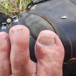
| Toe operation. I think I've managed to stop the ingrown nail. |


No comments:
Post a Comment