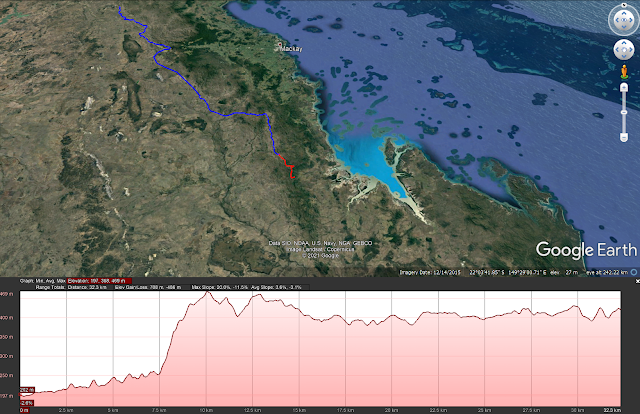
Tuesday 8th June, 2021 32.3km
1432.5 / 3666.4km
 |
| Deacey Homestead |
We chatted into the night but all of us are in bed early, so by 9pm all is quiet. We had discussed many things one of them was about my medication I should be taking. The thyroxine should be refrigerated and I only carry enough to get to the next resupply. This time however I left the 20 or so tabs I needed in my car in Hervey Bay. Anyway Leonie has the same medication and has arranged for her son to bring a strip of 26 tablets when he comes down to pick up the truck. Much appreciated by me but it means I don't head off early. In the end I accept a lift in the truck to the top of the pinch, the steepest part of the climb.
 |
| Top of the pinch |
 |
| A trail marker points the way |
I am also scouting for those behind me so I walk past the turn-off and go down to what they call the Killarney Dip Yards. The dip being a dip in the road. The trip down the hill is apparently overgrown and may not be suitable for the trailers Craig and Debbie are towing. The water down behind the Yards is clean and clear with a slight taste but overall good. Actually there is a lot of water in the dip. Not flowing but looks like it's spring fed.
 |
| The water at Killarney Dip Yards |
I walk back up the hill to the trail turn off. I follow the bearings as per the book. So far I've followed one bearing for 100 metres then changed to a second bearing for a kilometre that supposedly ends at a gate. In orienteering or rogaining the checks would be up to date. But with no gate then a 3rd bearing change for 700 metres to an old pole in the middle of the scrub means I am compounding errors by the time I'm supposed to change to 4th bearing.
 |
| the Schneider's Inn campsite |
I sit and contemplate and walk along the fence looking for a clue that will make me comfortable. About 600 north there is a gate in the fence and it does have BNT signs attached. I go get my pack and text Belinda to see if I have missed some update. The members pages has no official update. I take the third bearing and head down the hill. In my gut it just doesn't seem right so I only go about 500 metres and give it away and return to the gate. People have come up this way from the south but I can't find a definitive clue.
 |
| The view to the coast |
So return to the road and decide to take the long way round. tomorrow's 11km walk now becomes a 30km walk. Tonight's target is Schneider's Inn campsite at the top of the range overlooking St Lawrence.
I was probably right where I initially was but the clues are getting harder to see as the years go by. I did get to talk to the man from Killarney Station and he confirmed he put in a new fence and also cleared a fire break either side of the fence. He mentioned he did the old wagon line some years ago and I was probably right where I hit the fence. Someone needs to re-do the write up for this section.
I get to the camp spot just on dark. A couple tourists in a car roll up but I'm too tired to talk. There was a light shower of rain during the night.


No comments:
Post a Comment